- News
- City News
- nagpur News
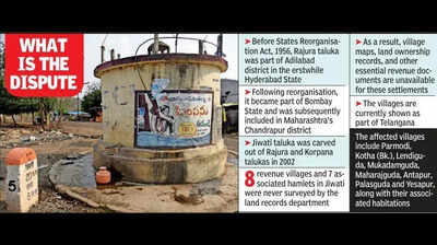
- Maha Sets Up High-Level Panel To Solve Border Row With Telangana On 15 Jiwati Villages
Trending
Maha Sets Up High-Level Panel To Solve Border Row With Telangana On 15 Jiwati Villages
End of Article
Follow Us On Social Media

Hot Picks
Top Trending
Tired of too many ads?go ad free now
Trending Stories
In Nagpur
In City
- Vidarbha researchers document fan-throated lizard Sarada deccanensis in Daryapur’s rocky grasslands
- Nagpur To Cannes, Manish Vaid Dresses Global Celebs
- ‘Temple of Justice’ Betrayed: HC Calls Court Clerk’s Funds Misuse a Matter of Grave Concern
- Maha Sets Up High-Level Panel To Solve Border Row With Telangana On 15 Jiwati Villages
- Mah delegates govt, nazul land approval powers to collectors, divn commissioners
- ATF stabilisation fund fuels Nagpur flight revival hopes
- Civic committee demands resumption of Goras Bhandar operations
- Hundreds march to Washim SP’s office over deadly attack on family
- Prashbadi stuns top seed Purvi in semis
- Chhatrapati, Vidarbha, Maharashtra Krida Mandal's Victorious March in KKM-8 kho kho
- ‘Talk to Mayor’ Firhad leaves after 8 yrs of pushing ahead on water supply, flood control, garbage fronts
- Court sends Swarup to cop custody till June 18, complainant says she was barred from work after she denied sexual demands
- Back in the saddle: Bengaluru to get 10.3km bicycle track
- TN govt seeks governor’s nod to prosecute Senthilbalaji in cash-for-jobs case
- Trees falling due to winds: Rampant concretisation to blame?
- Green initiatives pick up pace in state amid warnings of ecological stress
- Akal Takht backs justice for Henry Nowak, opposes hate-driven anti-Sikh narratives
- Villages spared as rural registrations see modest hike in Telangana
- Over 3,000 respiratory patients receive treatment under Mukh Mantri Sehat Yojana: Punjab health minister
- Govt doctors threaten jail duty boycott, seek action against misconduct
Tired of too many ads?go ad free now


Explore Every Corner
Across The Globe
Clavicular SurgeryYouTuber Jesse RidgwaUS Iran WarEarhquake in Himachal PradeshBrayan BelloMalviya Nagar Hotel FireHenry Nowak Murder CaseMaja ChwalińskaAnnamalai ResignationDianna Russini and Mike Vrabel ScandalDU Assistant Professor MurderDonald TrumpDamar Hamlin Cardiac ArrestCaitlin ClarkEmiliano MartinezScottie SchefflerMatthew KniesMorgan Riddle ControversyVaibhav SooryavanshiKCET Result 2026Connor McDavidScott EricksonNFL Trade RumorIndia T20I Squad AnnouncementDylan Larkin TradeAndy Robertson Net WorthPittsburgh PenguinsKylian MbappeKCET Result 2026Muhammad Ali ex Wife

Hot on the Web
Spanish ProverbGauri SprattSaif Ali KhanShah Rukh KhanRam CharanGreen AnacondaDhootha 2Baby NamesHai Jawani Toh Ishq Hona Hai ReviewShilpa ShindeBihar Riverfront ExpresswayPoonam DhillonRupi KaurNushrratt BharucchaKheera VS KakdiZhang YimingKJR RajeshGauri SprattCat BreedsSouth Delhi Restaurant TragedyJennifer LopezBandar Twitter ReviewWorld Environment Day 2026Drishyam 3 Box Office CollectionKaruppu Box Office CollectionDhurandhar 2 Box Office CollectionChand Mera Dil Box Office CollectionRERA FAQsJewar Airport ProjectsHoroscope TodayDelhi Malviya Nagar Fire4th Squadron S-400India Sudarshan ChakraFirstcry CompensationIAF France Jet DealHuman Evolving On Tibetan PlateauLargest Islands In The WorldJellyfish That Never DiesGoogle Release MosquitoesDelivery Firm Refund DeniedNyt ConnectionsCaptions For Instagram Posts
Trending Topics
KS BharatMaja ChwalińskaCapital Gains TaxDelhi Malviya Nagar Hotel FireAbhishek BanerjeeForex ReserveGurgaon Woman AssaultPokimaneJesse RidgwayCardi BRepo rateFIFA World Cup 2026Roman ReignsRussell Wilson Ciara Combined net worthHolly HolmNHL Trade RumorDylan LarkinTaylor SwiftSerena WilliamsSykkuno Cheating ControversyIran WarXI Jinping North Korea VisitVladimir PutinOman Oil Loading SuspensionBenjamin NetanyahuHezbollahLondon Tube Train IncidentHenry NowakPakistan LNG PurchaseAbbas AraghchiGoogle SearchRay DalioMatt GarmanDell XPS 13Larry Page And Sergey BrinWalmart ShareholdersNvidia Blackwell AI ChipAmy ColemanGarena Free Fire MAX Redeem CodesPeroxide CodesGenshin Impact Codes
Popular Categories
HeadlinesSports NewsBusiness NewsIndia NewsWorld NewsInternational SportsHealthBreaking NewsTravelAstrologyDeorhiTOI Young LeadersTOI Home Decor AwardsPower Creator Awards 2026TOI Ecopreneur Awards 2026Gold Rate TodayWeather TodaySilver Price TodayDelhi Weather TodayPetrol Price TodayDiesel Price TodayCNG Price TodayLPG Price TodayPetrol Price MumbaiDelhi AQIIs Bank Open TodayMumbai AQI TodayIs Bank Open TomorrowPublic Holidays in JuneBank Holidays in June
Trending Videos
From Tamannaah To Janhvi: Why Bollywood's Leading Ladies Are Embracing Faith Jimmy Kimmel Crushes CBS Rival As Stephen Colbert Exit Reshapes Late Night TVAkshay Kumar Pulls A Hilarious Prank On Rajpal YadavTaapsee Pannu Gets Candid On Identity, Growth And Public PerceptionPatna Protest Case: Khan Sir Booked Under Attempted Murder ChargeWhat Training 5 Lakh Indian Army Personnel In Drone Operations Means For Future WarsDelhi Fire Horror: Owner's Bangladesh-Linked Arrest Draws AttentionIndia Urges Faster Bangladesh Verification To Deport Illegal MigrantsTamil Nadu CM Vijay Holds First Cabinet Meeting, Signals New Governance Vision Another Attack By Putin's Forces? Largest Black Sea Port Bombed Days After Romania Drone BlastRoyal Lodge Cash Mystery: Andrew Mountbatten-Windsor's Secret Cottage Income ExposedTrump's Big Bet Pays Off: Massive Immigration Package Clears Key Hurdle; ’$70 Bn ICE Bill...'Congressional Blow To Trump: 4 GOP Lawmakers Buck Party Line On Key Vote | DETAILSIRGC Takes On Two US Warships At Once 'Racing Towards' Iran Coast; Missiles Fired, Troops On AlertShikar - Official TeaserShehbaz Sharif Hails Trump As ‘Man Of Peace’, Credits Him For India-Pakistan CeasefireWhite House Aides Go NUCLEAR Defending Trump After Viral 'Sleepy' Clip | WATCHTaapsee Pannu Unfiltered: Ageism, Sexism, Criticism & Motherhood | Her Vibe Ep 1 | Stutee Ghosh
Latest News
Hazaribag man drowns while fishing in lake"Behen Darr Gayi!": Fans relive ‘Bhagam Bhag’ era after watching Akshay Kumar's 'Bhooth Bangla' trailerMBOSE HSLC result 2026 to release tomorrow: Check details hereIran war risk: JPMorgan CEO Jamie Dimon warns of oil shocks, sticky inflation and higher interest ratesMake your clutch last longer with these easy driving tips“Three-against-one situation”: El Rubius opens up on being “targeted” in MrBeast’s viral $1M challengeBihar BTSC lab assistant notification released for 1091 posts at btsc.bihar.gov.in; apply hereIPL craze costs techie Rs 1.46 lakh in fake RCB vs CSK ticket scamRaising “robot-proof” kids: Why creativity and curiosity matter more than everInside ‘Satguru Sharan’: Exploring Saif Ali Khan and Kareena Kapoor Khan’s Rs 100 crore Bandra homeHow selling Alaska in 1867 was a costly mistake for Russia'Hera Pheri 3 is coming': Paresh Rawal dismisses delay reports and reveals he will 'start shooting soon'US-Iran War: A daring rescue Hollywood blockbuster is on its way. Till then, pick your favourite from these 10 films on bringing someone home against all oddsKolkata team unveils fan mural at Rash Behari Avenue, celebrating city’s first loveHow US spread a lie to rescue a pilot of a jet shot down in IranNetflix unveils ‘VOID’, an AI model that can change a movie plotAI data centers are causing 'stress' not just to tech companies, but also private insurers"Trans women are.....": Clavicular’s viral moment with trans women sparks fresh conversation on internet culture
Copyright © 2026 Bennett, Coleman & Co. Ltd. All rights reserved. For reprint rights: Times Syndication Service